Kythira
3.8/5The forgotten island — Venetian castles, wild gorges and deserted beaches
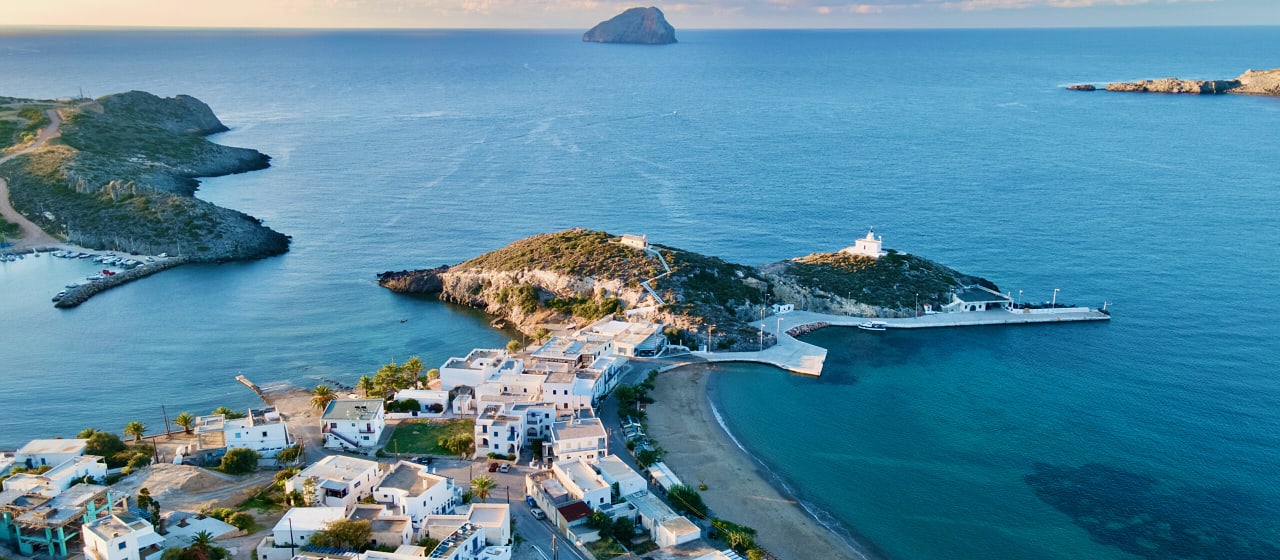
Chora's Venetian castle, the cave of Agia Sofia, the waterfall gorge of Milopotamos and the deserted beaches of the south coast.
Why 3.8: exceptional history and architecture and very good beaches — but you cannot do it without a car.
Kythira is the island the crowds forgot, and it stays that way because it is hard to reach. Administratively part of the Ionian islands but geographically alone south of the Peloponnese, it is one of the least-visited significant islands in Greece — 279 km² of Venetian architecture, Byzantine ruins, gorges, and beaches that are almost always empty. Chora is a narrow ridge of blue-doored whitewashed houses under a 13th-century Venetian castle; Mylopotamos hides the Neraida waterfall, and below it the sea cave of Agia Sofia holds 12th-13th-century frescoes on the rock. Fyri Ammos is red sand off a dirt track and Kaladi is a thirty-minute path in. The Australian community (thousands emigrated in the 1950s, and half of Greek-Australians have Kytherian roots) gives the island a distinct cultural character and returns en masse every July. Skip it if you won't hire a car — at this size Kythira simply does not work without one — and there is no Piraeus ferry: a flight, or a five-hour drive to Neapoli. June is the honest best month: sea warming, Kaladi and Diakofti still parkable, the castle climbable without the heat.
Good for
- Travellers who want an island the crowds forgot — Kythira is one of the least-visited significant islands in Greece
- Anyone drawn to Venetian castles and gorges — the Chora castle, the Paleochora ruins and the Neraida waterfall at Mylopotamos
- Beach-hunters willing to walk — Kaladi is a thirty-minute path in and Fyri Ammos is red sand off a dirt track
Maybe skip if
- If you won't hire a car — at 279 km² Kythira simply does not work without one
- If you want a simple hop from Athens — there is no Piraeus ferry, so it's a flight or a five-hour drive to Neapoli
Getting there
Small airport with daily Athens flights (Olympic, Sky Express). No Piraeus ferry — reach Kythira from Neapoli (Peloponnese SE, ~5h drive from Athens) by frequent ferry, ~1h.
Tip: For a short trip, fly. The Peloponnese drive only makes sense if you want to see Mani too.
Best time to visit Kythira
Kythira is technically Ionian but feels different — south of the Peloponnese, drier, more rugged. Long ferry from Piraeus, but also accessible from Neapoli on the Lakonian coast. Best May-October. The Easter celebrations in Mylopotamos are particularly beautiful. Authentic, slow, never overrun — the island the diaspora returns to.
Top beaches of Kythira
Fyri Ammos Beach
The most beautiful beach on Kythira — distinctive red-orange sand (fyri ammos = red sand) in a sheltered bay on the east coast. The unusual sand colour and crystal clear water make it unforgettable. Almost always quiet.
- Type
- Fine red sand
- Length
- 400 m
- Depth
- Medium — clear, calm water
- Wind
- Avoid visiting when the wind blows from the northeast to southeast at over 5 Bft. East-facing — sheltered from the Ionian's afternoon maïstros (NW breeze); typically calm all day
- Facilities
- Basic: accessible by dirt track. Small beach bar in summer.
Kapsali Beach

Twin coves directly below the castle of Chora — the most convenient beach on the island for those staying in the capital. Clear water and the extraordinary backdrop of the Venetian castle make it special.
- Type
- Pebble and sand
- Length
- Two coves, each 200m
- Depth
- Medium — clear Ionian water
- Wind
- Avoid visiting when the wind blows from the southeast to southwest at over 5 Bft. South-facing — sheltered from the prevailing NW winds; calm in summer, exposed only to rare southerlies
- Facilities
- Good: sunbeds, tavernas, boat hire. Chora castle visible above.
Kalami Beach
A remote pebble beach below the gorge of Milopotamos, accessible only on foot via a steep path or by boat. Dramatic cliff scenery and exceptional water clarity. Almost always completely empty.
- Type
- Pebble
- Length
- 200 m
- Depth
- Deep — crystal clear water
- Wind
- Avoid visiting when the wind blows from the southwest to northwest at over 4 Bft. West-facing — exposed to the afternoon maïstros (the Ionian's NW summer breeze); glassy mornings, waves by late afternoon
- Facilities
- None — steep path or boat access only.
Kaladi Beach

A wild, isolated pebble cove accessible only on foot. Deep turquoise water and complete solitude. One of the finest swimming spots in the south Ionian for those willing to walk.
- Type
- Pebble
- Length
- 150 m
- Depth
- Deep — turquoise Ionian water
- Wind
- Avoid visiting when the wind blows from the northeast to southeast at over 5 Bft. East-facing — sheltered from the Ionian's afternoon maïstros (NW breeze); typically calm all day
- Facilities
- None — 30-minute walk on foot only.
4-day itinerary for Kythira
Read the day-by-day plan on its own page →
Day 1: Chora & the Castle
- 09:00 · Chora (Kythira Town)
One of the most beautiful Venetian towns in Greece — a narrow ridge of blue-doored whitewashed houses below a 13th-century Venetian castle. The views from the castle over the sea are extraordinary.
- 09:30 · Venetian Castle of Kythira
Well-preserved 13th-century Venetian fortress with a complete enceinte wall and internal streets. Below the castle, the sea drops sheer 100m to the water.
- 11:30 · Archaeological Museum Kythira
Excellent collection tracing the island's extraordinary history — Minoan, Phoenician, Byzantine and Venetian. Kythira was a major trade crossroads for 3000 years. - 14:00 · Kapsali Beach
Twin coves below Chora — the port beach with clear water. The castle is visible on the cliff above. Good tavernas, calm water. - 🍴 Stop for dinner · Chora & Kapsali — see Eat & Drink below
- 21:30 · Drive back to Avlemonas
Drive back to the eastern coast (about 30 minutes from Chora). Avlemonas is silent at night — just lapping water against the rocks and the lights of fishing boats. Perfect for a nightcap on the harbour.
Day 2: Milopotamos & the Waterfall
- 09:30 · Milopotamos Village
🚗 ≈30 min west of Avlemonas
The most beautiful village in Kythira — a Venetian settlement above a river gorge, with a waterfall, plane trees and an extraordinary abandoned lower village (Kato Chora) with Venetian walls intact.
- 10:30 · Neraida Waterfall
Walk down through the village to the waterfall — a small but beautiful cascade into a natural pool surrounded by oleanders. One of the most unexpected spots in the Ionian islands. - 12:00 · Cave of Agia Sofia
A spectacular sea cave with a Byzantine church inside — frescos from the 12th-13th century survive on the cave walls. One of the most unusual religious sites in Greece. Guided tours from the village.
- 15:00 · Kalami Beach
Remote pebble beach below Milopotamos, accessible by a steep path or by boat. Extremely clear water, dramatic cliff scenery, almost always deserted. - 20:30 · Drive back to Avlemonas
Drive back across the island to Avlemonas (about 40 minutes from the west coast). The harbour's small tavernas serve fresh-caught fish — an ideal late dinner under the stars.
Day 3: Avlemonas & the East Coast
- 09:30 · Paleopolis Beach
Long sandy beach near the ancient city of Scandeia — one of the longest on the island. Sandy, calm and rarely crowded. The ancient harbour ruins are visible offshore.
- 12:00 · Avlemonas
The most atmospheric harbour in Kythira — a Venetian fortress above a tiny circular fishing harbour. Lunch at one of the waterfront tavernas. Exceptional fresh fish.
- 🍴 Stop for dinner · Avlemonas — see Eat & Drink below
- 14:30 · Fyri Ammos Beach
The finest beach on the east coast — fine red sand (fyri ammos means 'red sand') in a sheltered bay. Clear, calm water. Accessible by a dirt track. - 16:30 · Kaladi Beach
Small, wild pebble beach accessible only on foot (30 min walk). Deep turquoise water and complete solitude. One of the best wild beaches in the Ionian. - 19:30 · Drive back to Avlemonas
Drive back from Kaladi (about 25 minutes). Last evening — settle into a taverna with a view of the harbour, order octopus and white wine, and watch the sky turn pink over the rocks.
Day 4: North Kythira & Departure
- 09:30 · Potamos Village
🚗 ≈40 min north of Avlemonas
The largest village on the island and the main commercial centre. Sunday market is the social event of the Kythira calendar — locals from across the island come to shop and socialise.
- 11:00 · Agia Pelagia Beach
Sandy beach at the northern ferry port. Calm, organised, good facilities. The ferry to Piraeus and the Peloponnese leaves from here.
- 15:00 · Diakofti Port — Departure
Main ferry port in the east — connections to Neapoli, Piraeus and the other Ionian islands. The ferry ride south reveals Kythira's dramatic coastline from the sea.