
Gavdos in 3 Days
Sarakiniko base on Day 1, Trypiti to the southern edge of Europe Day 2, the lighthouse and northern beaches Day 3.
Gavdos in 3 days, day by day: what to see, in what order, how far you drive and where you sleep. Base: Sarakiniko. It works without a car.
Karave, Kastri & Sarakiniko
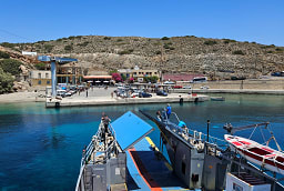
Karave Port
The only proper harbour on Gavdos — a single concrete pier, one year-round café (Evangelina's), the bus that meets every ferry. Bring everything you need; supplies on the island are minimal and expensive when shipping is delayed by weather.
Kastri (Capital)
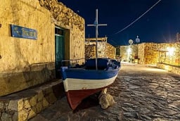
The administrative 'capital' — a hill village with a few stone houses, a small clinic, the only post office, the police station (one officer). Walking around takes ten minutes. Rakopagida kafenion serves Kalliopi's home cooking — souvlaki, gyros, baked feta, simple and good.
Sarakiniko Beach 🏖 beach card · wind & conditions →
1.5km north of Karave — a long blonde sand beach hidden behind dunes and a juniper forest. Named after the Saracen pirates who once used the island as a base. The most equipped beach on Gavdos: rooms for rent, tavernas, a mini-market, sometimes free live music in summer. Many free campers under the junipers.
Walk to Agios Ioannis 🏖 beach card · wind & conditions →
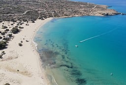
Easy 1-hour coastal trail west from Sarakiniko. Agios Ioannis is the most striking beach on the island — golden dunes, cedar trees down to the water, turquoise sea. Discovery Channel once ranked it the second-best beach in the world. No facilities at all. Common nudist beach. Natura 2000-protected.
Walk back to Sarakiniko 🏖 beach card · wind & conditions →
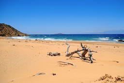
Walk back along the dirt path to Sarakiniko (about 1 hour from Agios Ioannis). The campsite area has the only real evening scene on the island — informal tavernas under tamarisks, no lights to obscure the stars.
Trypiti — The Southern Edge of Europe
Korfos Beach & Settlement 🏖 beach card · wind & conditions →
2km south of Karave on the northwest coast. Pebble beach with calm clear water, a few rooms to rent, two tavernas. Panorama Taverna at the highest point of the settlement does the best fish on the island, with Libyan Sea sunset views. Trailhead for the walk to Trypiti.
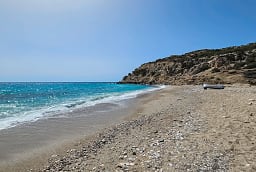
Korfos to Trypiti Hike 🏖 beach card · wind & conditions →
5km / 2-hour coastal trail south through Mediterranean scrub and cedar forest. Passes a salt pan that hosts migratory birds in spring (resting on their crossing from Africa). Ends at the Trypiti beach and the famous southern cape.

Trypiti — The Giant Chair 🏖 beach card · wind & conditions →
The southernmost point of Europe — Cape Trypiti, with three natural rock arches (the 'Kamarelles') carved by the sea. On top sits a concrete sculpture of an oversized chair, placed there in 1997 by a group of Russian physicists who came to the island to find immortality and never left. Climb up, sit, look at Africa across the Libyan Sea.

Trypiti Beach 🏖 beach card · wind & conditions →
Below Cape Trypiti — sandy on the eastern side, large stones and pebbles closer to the cape. Crystal clear water, complete isolation. The southernmost swim in Europe. Bring water, food, shade — there is nothing here.
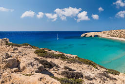
Walk back to Sarakiniko 🏖 beach card · wind & conditions →
Walk back from Trypiti (about 1.5 hours including the climb out). Bring a torch — the path back is unlit and the night sky over Gavdos is one of the darkest in Europe.
Lighthouse, Ambelos & Potamos
Vatsiana Village
The southernmost village in Europe — 31 permanent residents. Stone houses, abandoned terraces from when farmers grew crops on the hillsides, a tiny folklore museum. Trail south leads to Trypiti (alternative to the Korfos approach).

Gavdos Lighthouse
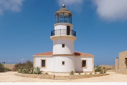
Built 1880, restored as a museum + summer café. At 368m altitude with the best sunset view on the island and (on clear days) the African coast visible on the horizon. Climb the tower for the panorama. Wooden chairs outside on the rocks for sunset drinks.
Ambelos to Potamos Hike
Well-signposted 1.5-hour trail descending from Ambelos village through abandoned stone houses and a small gorge to Potamos beach on the northwest coast. Steep ending. Views of Gavdopoula islet across the strait.
Potamos Beach
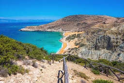
Red-sand beach on the northwest, accessible only on foot or by boat. Crystal water, completely undeveloped, a few hardcore campers giving it a proper 'end of the world' feel. The reward swim for the hike.

Planning questions
Is 3 days enough for Gavdos?
Yes, for a first visit. The plan covers the essentials at a pace that leaves time in the water. With one more day, add a slow beach day with no driving.
Do I need a car on Gavdos?
No. This plan works on foot, by boat and with the local bus.
Where should I stay on Gavdos?
The plan sleeps in Sarakiniko.